
With an abundance of misinformation out there, find the truth and official answers here to keep you, friends and family properly informed.
01. Why a cable car? Have alternatives been considered?
In 2011 an endeavour was undertaken to identify and resolve the existing and long term forecast issues surrounding access and amenity on kunanyi/Mount Wellington. This study concluded that a commercial, private sector solution was more appropriate than a government funded exercise due to economic and social conditions. A terms of reference was established to look into every plausible transport technology that could scale the height of kunanyi/Mount Wellington.
Building on the 2009 Sustainable Transport Study commissioned by the Wellington Park Management Trust, consideration for a Funicular, Aerial Cable Car, Cog-Railway, Light-rail, Shuttle Buses and All-terrain vehicles were examined in closer detail. Lines of communication were opened with various operators and manufacturers of these systems to obtain factual and relevant technical limitations. The build costs, operating costs and maintenance of each system were forensically compared, as was the noise emissions, carbon emissions, system capacity, turn-around time, queue length and wait times each system offered. Ride comfort and tourism experience ratings were also determining factors.
Systematically, a process of elimination that tested the technical, economic and environmental factors of each transport option narrowed. Aerial cableway won this contest hands down when tested on all parameters and community expectations.
A Cable Car, done well, is deemed appropriate and in principle is consistent with the objectives Wellington Park.
MORE ON: CABLE CARS
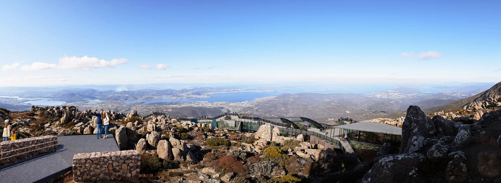
02. What facilities will be at the top?
MWCC's proposal includes a 'Pinnacle Centre' that will house a raft of public and commercial facilities. These include:
PUBLIC FACILITIES: •Visitor/interpretation centre, •Educational tour operator, • New observational platform • New, enclosed 24/7 accessible emergency shelter • New toilets and parenting rooms, • Park rangers office/storage • Rubbish & recycling bins • CCTV and overnight security
COMMERCIAL FACILITIES: • All day cafe •Restaurant / function venue • Tasmanian wine and whisky bar • Sports lockers & Gift Shop
Our proposal includes the cost of building and maintaining the public facilities. There is no entry fee into the Pinnacle Centre, and all visitors traveling by road to the summit will be welcome.
MORE ON:[FACILITIES]2
03. Where will it start?
Our proposal has been carefully crafted to minimise visual impact and disruption from crosswinds, whilst maximising environmental benefits and the visitor experience. After an in-depth study in 2012/13 assessing nine potential route alignments against climatic, geographic and social conditions given to us from our phase 1 public consultation process, the most optimal alignment from the summit runs East-West, in the lee of the Mountain's prevailing winds.
Our Base Station is proposed to sit just inside the boundary of Wellington Park, on an existing clearing along the Main Fire Trail. This spot allows for the most optimal alignment to have no more than a single tower near the summit, that also sits below the skyline when viewed from the city.
Two other frequently suggested starting locations have included The Springs and Tolosa. Our response to these is as follows:
- Our study concluded that The Springs route would require too many large towers across the face and on top of the mountain and would financially struggle without road use restrictions.
- The Glenorchy City Council have granted MWCC conditional landowner consent to further investigate Tolosa, and we also have private landowner options in the vicinity. Preliminary analysis suggests more towers visible on the skyline than our optimal route, and would overall be more susceptible to suspensions due to excessive exposure to the prevailing westerly winds.
**MORE ON:**MASTERPLAN
04. How much will a ticket cost?
MWCC has formally announced that Tasmanians will benefit with special pricing, with a Family return ticket costing just $64 for 2 Adults and all dependant children under the age of 17.
Further ticket prices will be announced after planning approval, with a wide ticket choice available including one way, concessions and season passes for the outdoor enthusiast.
Standard tickes will be valid for 24 hours whilst season passes will be available to provide unlimited one-way or return access for outdoor enthusiasts during a valid season.
05. How fast will it be?
Our planned operating schedule is to depart every 15 minutes which allows 2 minutes of loading time and 13 minutes of quiet, spectacular transit. This allows visitors to cherish the experience of their journey ascending the mountain, whilst learning some of its wonderful heritage from our friendly onboard cabin attendant. In the event of any emergency, our system speed can be increased to complete the trip in 5.7 minutes.
06. What are the proposed opening times?
MWCC is set to provide flexible operating hours to align with daylight hours, snowfall, public holidays and special events. For example, we expect to operate continuously through dawn on New Years Eve/Day. On average we anticipate the following schedule:
- 9 hours per weekday in winter,
- 10 hours per weekend day in winter,
- 13 hours per weekday in summer.
- 14 hours per weekend day in summer
07. How many people can it move per hour?
Whilst we only expect to carry 60-70 people per hour on average, (15-18 per trip) our proposed system is designed to carry a maximum of 650 people per hour per direction. This provides rapid emergency evacuation of the summit if required, and ease of access on the mountain's busiest days such as sporting events, two cruise ships simultaneously docked in Hobart or when a large dump of fresh snow is followed by a weekend of sunny blue skies!
This capacity also allows two school classes to keep together with their teachers and minders, and offers flexibility to freight supplies and waste on and off the mountain.
08. How many towers will it need, and how high?
Cableway towers come in many shapes and sizes. We’ve designed our cable car system to achieve the lightest footprint on the Earth as possible.
From our Base Station just inside Wellington Park, we propose just 3 towers to reach the proposed Pinnacle Centre. Two towers are located close to the base in the lower foothills to lift the cabins above the forest canopy as quickly as possible. These towers will protrude above the forest canopy some 15 metres.
From there, our proposal features a 2.1km single span up the mountain face, providing zero footprint between tower 2 in the foothills and the final tower 3 near the top, just below the proposed Pinnacle Centre.
Tower heights vary according to the existing forest canopy and will generally decrease with height above sea level. Existing towers on and around the mountain include the Broadcast Australia 'stick' at 131 metres, WIN TV tower at 90metres, and the Chimney Pot Hill radio tower at 71 metres. Our highest tower will be just 36 metres tall. Importantly, this height keeps the tower BELOW the skyline when seen from the city. Other routes to the North or South would require several towers near the summit and other explored options would require these to be seen above the skyline.
Aesthetics of the towers will be considered in more detail as we progress further. Like other tourism cableways such as Skyrail in Queensland, it is envisaged that camouflage paint may be used to blend their appearance further with the natural environment.
09. What is the wind speed limit?
Wind direction is just as important as speed. Our proposal has been carefully designed to be predominately sheltered from the prevailing westerly winds. Whilst head-winds aren't a concern for the Skytram, it is the northerly cross-winds that we'll be actively monitoring. 40+ years of weather data suggest winds above our manufacturer's safety limit will occur at around 2.25% of our operating schedule.
We've established an operational limit of 80km/h N/NW as a comfort threshold and used the historical frequency of this occurring around the sheltered lee of the mountain in our business model. This threshold is lower than the system manufacturer's limit and will be adjusted if required once operational.
10. Will there be a 'Scar'?
No. A corridor of cleared vegetation, similar to the requirements of high-voltage transmission lines, is not required under the cableway. The social conditions impressed upon MWCC by the Tasmanian public clearly state that for our project to be socially acceptable we must not clear swathes of vegetation up the mountain face. And why would we want that anyway?
In response, our proposal will carry visitors high above the forest canopy rather than through it. This requires taller towers but substantially reduces the overall visual impact from near or far. See question 8 above.
We have also employed the general manager responsible for delivering Skyrail, an global award-winning ecotourism attraction across a World Heritage rainforest near Cairns, Queensland. Mike rewrote the book on how to build cableways in sensitive environments and shares our ethos for showcasing - rather than exploiting - the environment we seek to protect.
Minimising our environmental footprint has been a very important factor and so our engineering team have come up with an impressive solution that not only floats above the forest canopy, but also has significantly reduced the number of towers required since the previous proponent. This optimal solution is technically possible on Mount Wellington specifically because of the steep vertical rise offered by the Organ Pipes.
In response to rock-climber concerns, and adopting the advice from other seasoned operators, MWCC does not intend to apply lubricant to the system cables. Whilst this shortens the life-cycle of our cables it negates any chance of oil dripping on climbing routes directly below the system. This ensures our environmental and recreational impact is benign.
11. What about the skyline?
We aim to not just protect it, but restore it where possible. This issue is so important for us that we took the extraordinary step of requesting an amendment to the Wellington Park Management Plan in 2014 to adjust the boundary of the Pinnacle Zone. This was to ensure the planning scheme better aligned with what the community have told us they want. This was successfully ratified on the 4th Nov 2015.
Unlike the existing observation shelter, we gave ourselves an extra design challenge to find a way to ensure the summit facility doesn’t restrict the view when looking at the city from the top of the mountain.
MORE ON:VISUAL IMPACT
12. Will the road need to be closed or restricted?
No. Our phase 1 and 2 public consultation activities clearly asked us to ensure our business model required no changes to the management of Pinnacle Road. This key criteria played an important role in our assessments of alternative transport systems and is a key reason why, through a process of elimination to determine which transport method could co-exist with the road, that an Aerial Cableway system was ultimately chosen to complement our project. Together, the road and our cableway can provide improved reliability of access to the pinnacle year round.
Without a cable car providing revenue to the Park, it is likely that all mountain visitors will soon have to pay a fee to drive up the mountain, or may be forced onto a user-pays shuttle bus.
13. How does it compare to 'doing nothing'?
Without a cable car providing much needed revenue to the Park, it is likely that all mountain visitors may soon have to pay a fee to enter the Park, drive up the mountain, or be forced onto a user-pays shuttle bus.
In times of peak demand/visitation to the mountain, the cableway can excel at offering comparable hassle-free transport without the congestion, emissions or queues currently experienced on the road. At a maximum capacity of 650per hour, our Preliminary Proposal is designed to cater for twice the record daily number of visitors. (August 2010 & September 2021).
Environmentally, the inclusion of a cable car on kunanyi / Mount Wellington is set to reduce the road vehicle count significantly year round. Our projections estimate up to 60% fewer cars and buses in Wellington Park once operational. For every vehicle removed from the road, the net environmental impact is a reduction on the 2000+ tonnes of carbon currently emitted transporting people to and from the top.
We are already in positive talks with many tour bus operators who are likely to abandon driving to the summit in favour of servicing the base terminal. The positive impact here is safer, quieter road use for cyclists, other motorists and residents along Huon Road and Pillinger Drive. Less traffic also reduces the risk of wildlife ending up as roadkill, especially after dark.
Pinnacle Drive was built in an era where motorised traffic volumes & future growth were not a key concern. To upgrade this road to modern AusRoads standards to add another 75 years lifespan would require significant widening at government expense. Cut & fill civil earthworks all along the 12km length to the summit, predominately on the visible mountain face, would ultimately result in a great deal of disturbance to the natural environment (and severely limit access during its reconstruction). It took decades of natural vegetation to regrow and hide 'Ogilvie’s Scar'; and it would take several more to hide any new such works. Upgrades to Pinnacle Drive (to improve its safety, accessibility and/or lifespan) would be a direct impost on public funds and would take away much needed funds from other (more) high-priority government expenditure.
14. How much will it cost to build?
The total calculated cost for the entire proposal including the free public facilities at the summit is now in excess of $80 million. Included is a $6 million budget for public infrastructure upgrades such as new, safer and compliant boardwalks and proper bathroom amenities at the pinnacle, as well as spacious, architecturally designed lookouts and seating. The primary outdoor lookout at the summit has been quietly removed by council.
15. What about Maintenance?
Maintenance, Safety and associated funding will be managed in accordance with best practice protocols established by the Swiss Federal Office of Transport; Bundesamt für Verkehr BAV and as adopted in Australia. AS per comparable operators in Australia, New Zealand and South Africa, MWCC will set aside and deposit a percentage of revenue each year into a Capital Reserve Trust Fund (CRTF) as a way to amortize the cost of maintenance over the long term.
Our CRTF account then covers all minor annual maintenance, major 12 to 15 year rolling maintenance and upgrades as well as refurbishments, ensuring a sustainable business practice.
It is likely that annual maintenance on the entire system will occur across a few days in late May to coincide with historically lower visitor numbers, and before popular winter festivals commence.
16. How is the project financed?
The project is privately funded by its founders and predominantly Tasmanian shareholders that wish to ensure a sustainable and proud future for the Mountain and Tasmania's next generation. There is currently a waiting list of Australian investors.
Once approved, additional shares may be offered for sale to allow more Tasmanians to be part of the big build.
17. Can anyone buy shares?
Not at this stage. Mount Wellington Cableway Company Pty Limited (MWCC) is a privately held enterprise. As we are not a publicly-listed company on the ASX, shares are not for sale to the general public.
Anyone genuinely interested in joining our investment waiting list or making a bequest is more than welcome to contact our CFO and Compliance Director.
18. Is the Government expected to pay for this?
No. MWCC is not seeking government assistance to pay for our commercial venture.
Furthermore, our adoption of the highest maintenance, standards and safety protocols set by the Swiss Federal Office of Transport; Bundesamt für Verkehr (BAV) will ensure our business model is self-sustainable for the long term (as do our comparable operators who have been in business for decades). This means Tasmanian taxpayers will not be left with a liability.
19. Is it viable?
Comprehensive feasibility conducted by Point of Interest cableway consultants Riser + Gain has been analysed by several business analysts and industry experts. Additionally the Tasmanian Development Board conducted an independent and comprehensive analysis of the business case for the State Government in 2016.
Financial due diligence has been individually conducted by investors and their financial advisers before purchasing shares in MWCC. Importantly, the business case relied on current and historical tourism visitation data in Hobart & Tasmania (not projected forecasts), along with a variety of other overly conservative cost measures and worst case scenarios.
Research data, financial modelling, breakeven analysis and the business plan are considered core Intellectual Property (IP) of MWCC and will not be publicly disclosed for commercial reasons.
20. What happens if it fails financially?
If this venture fails to provide an adequate return on investment for our shareholders, several options can be actioned. As a last resort, the system can be decommissioned and dismantled with costs paid for by our Capital Reserve Trust Fund (CRTF). Parts will be sold on the global second-hand market.
Nonetheless, it is incredibly rare for a cable car system to shut-down due to economic factors. Most decommissioning occurs where cable cars have been installed as a temporary attraction for sporting events, festivals or international exhibitions. Members of our project team have been involved in a number of installations and relocations for these purposes and understand the process well.
21. How does the rest of Hobart benefit?
Most importantly, our preferred leasing arrangement would be structured in a way to ensure sufficient funds are directed back into properly resourcing park management, maintenance of facilities and conservation efforts.
Respected economist Saul Eslake has endorsed a robust macro-economic impact report written by 42 South Consulting. In 2016 this suggested MWCC operations would boost the broader economy by $79-99 million per annum. Post-Covid analysis in 2024 revised this impact to $129m per annum.
Notably, MWCC can help reduce seasonality of the tourism industry, driving more resilient market appeal to the region and helping fill hotel rooms through Hobart's slower winter months. Historical visitation data for the mountain shows a peak visitation period around Christmas/New Year, followed by a 2nd peak period (albeit sporadic due to road closures) in late winter/early spring due to the onset of snow.
Tickets will be valid for 24 hours so passengers can defer their trip should they choose not to travel during inclement weather. This deferral may even extend a visitor's time spent in Hobart along with their expenditure at other businesses.
Mountain Biking for locals is set to improve dramatically with new connections around the Main Fire Trail trailheads, and access onto McRobies Road set to better link existing lower foothill trails with the existing road network. At the pinnacle, a new even-grade trail will connect Pinnacle Road directly with the summit station loading platform.
Additionally, a large percentage of anticipated passengers will be encouraged to pre-purchase tickets online before embarking on their trip to Hobart or Tasmania. By removing this expenditure from a tourist' daily budget, it reduces the prospect of cannibalising the benefit to other local businesses whilst tourists are in town.
22. What is the likely traffic impact?
The road to the summit will remain open and free with our proposal, but we seek to reduce the vehicle traffic up and down the mountain. This includes the residential and rural zoning of Pinnacle Road, Pillanger Drive and Huon Road as much as possible, which is to the benefit of Fern Tree & Neika residents, native wildlife and our city's carbon reduction goals.
Our Traffic Impact Assessment suggests up to 60% fewer cars and buses accessing Wellington Park via Pinnacle Road once operational. (42% min - 60% max)
This is offset by a forecast increase of 2.84% in vehicles each way (5.68% total) on Upper Macquarie St and Cascade Road; an arterial road currently servicing over 3 million vehicle trips each year. At peak times, Cascade Road is only at half its built capacity and serves a mixed urban zone including the municpality tip, hospitals, schools, churches, aged care and childcare facilities, heavy industries, tourism attractions and sporting venues.
The marginal annual average increase of our operation on Cascade Road is 1 additional vehicle every 79 seconds during our operating hours.
The net difference in annual carbon emissions between accessing the summit and the Base Station is close to 2000 tonnes per annum. The more we can incentivise mountain visitors to use the cableway instead of the road, the more we can help reduce carbon emissions.
23. Will this project privatise the mountain?
No. The State Government has legislated to purchase land from Local Government if and when our Development Application is approved. It will remain public land.
It is our understanding that we will lease the land from the Tasmanian Parks & Wildlife Service, and we hope that this new revenue stream is invested directly back into the upkeep and preservation of Wellington Park. We have no intention to fence off our lease boundary so public access will remain largely 'as is'.
Commercial leases already exist on the mountain, with both Broadcast Australia and WIN Television leasing land for their transmission facilities from the Hobart City Council.
24. How many jobs will this create?
- 200 jobs during an 18 month construction phase,
- 80 operational jobs.
25. Can it avoid the Organ Pipes?
The pinnacle sits on the eastern/city side of the Wellington plateau, and is surrounded by a 800metre wide escarpment (the Organ Pipes) in an arc from South-East to North-East. Several route alignments were studied and considered throughout preliminary and detailed design phases.
Detailed design investigations determined two key findings:
- The route would need to be aligned within the sheltered side of the mountain to be protected from prevailing westerly winds, and
- The upper terminal would need to be located directly east and below of the existing Observation Shelter to best minimise impact to the mountain's skyline.
In more detail, the upper terminal location finding has been key because the eastern side of the pinnacle (sloping towards the city) offers a series of naturally-formed flat tiers that can discretely position a visitor centre. Investigations have determined that using this location maximises the chance a visitor centre can best sit below the skyline, whereas this outcome is not possible on any other direction sloping away from the pinnacle.
A northern alignment that avoids the Organ Pipes, such as from the western fringe of Lenah Valley or Glenorchy, not only results in new building structure visible above the mountain skyline, it also requires many more, and taller, towers than the proposed alignment. Aside from visual and environmental impacts, there are critical technical, operational and safety reasons why a northern alignment are not feasible. These include prevailing cross-winds, operational reliability and visitor safety.
WHAT ARE THE ADVANTAGES OF ASCENDING THE ORGAN PIPES?
Fortuitously, siting an upper terminal in the optimal eastern location of the Pinnacle shortens access considerations from the urban fringe. A well-designed cableway system that ascends the mountain up its steepest eastern slope can significantly reduce construction footprint and visual impact by minimising the quantity of support towers. Importantly this approach also avoids all water catchment zones that are prevalent north, west and south of the Pinnacle.
MWCC note that throughout the past three decades, including our own community consultation programs since 2011, it has long been assumed within the public domain that an alignment would ascend over the Organ Pipes. This was rarely raised as a key concern compared to other critical community guidelines which MWCC has worked hard to resolve in a feasible proposal.
Not only are they spectacular to see up close, the vertical drop offered by the Organ Pipes can significantly reduce the number of towers for a cableway. Our multi-national design team determined how to have just one tower between the Organ Pipes and the Pinnacle, with no towers below the cliffs for two kilometres. This minimised solution largely preserves the eastern mountain slopes from infrastructure and drastically reduces potential visual impact and footprint, compared to other potential alignments. Furthermore, MWCC's design team worked hard to micro-site this summit tower to reduce its height and bulk as much as feasibly possible, ensuring it sits below the mountain's skyline to not impact on the iconic view from the city and waterfront.
26. WHY AN AERIAL TRAMWAY?
Of the various types of cableway, Aerial Tramway has been selected as the best solution for the Mountain. Listed below are some of the key reasons why:
- considerable less towers required than gondolas (3 versus 13) on the same alignment. (less footprint & visual impact)
- only 2 cabins (compared with over 50 smaller cabins) are needed to match visitor demand. (less visual impact)
- tramway stations are much shorter than gondola stations, meaning if placed well, can sit below the mountain skyline. A gondola station would otherwise need to be located on the existing carpark (and exposed to the prevailing winds)
- tramway station sizes can be fully-customed to suit the site. MWCC has optimised the platform configuration to minimise size.
- tramways can carry much larger and heavier needs, which allows all freight, maintenance, good supplies and waste to be transported off the mountain via cableway, negating the need for any access road from the summit to reach the pinnacle centre.
- the size of our tramway cabin allows school group excursions to stick together, and may be used for a variety of other uses as well.
- tramways offer the highest top speed, should rapid evacuation from the summit be required or when major events are on (i.e spectators and participants in cycling, running and walking events that scale the mountain.)
MISSING A QUESTION & ANSWER YOU THINK WE SHOULD ADD? PLEASE LET US KNOW.
